Taivaskero trail as well as many other nature trails have been unusually popular in the summer of 2020 because of the corona situation. This was obvious in July on the parking lot of the Pallastunturi Visitor Centre, the perfect starting point to many fine hiking trails. The Centre is a one-stop-shop for information about hiking and services in the area and also offers changing exhibitions.
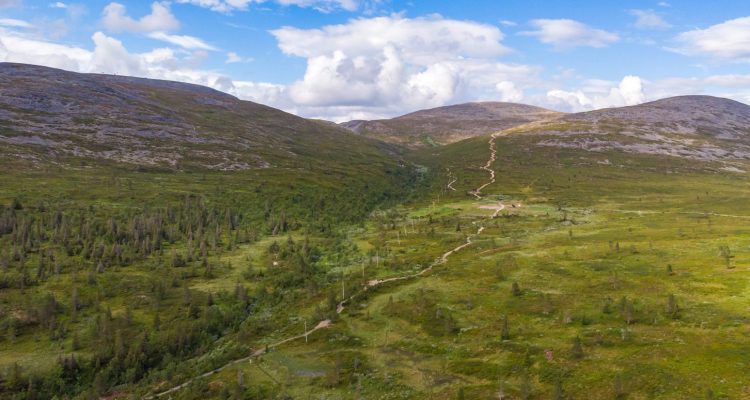
Pallastunturi fell is part of the Pallas-Yllästunturi National Park, our third largest national park consisting of over 1000 square kilometers. There is a total of 340 kilometres of marked summer trails in the Pallas-Yllästunturi area for short day trips and long hikes. See also: National parks in Finland.
Seven fells
The Pallastunturi Visitor Centre is surrounded by seven fells, with heights ranging from Pallaskero’s 646 metres to Taivaskero’s 809 metres. Kero means a treeless and round top area on a fell. The starting point to the trails is at 450 metres asl, giving you a maximum height difference of 360 metres. The available routes can be seen on the Pallas trail map provided by Metsähallitus. There are restrictions for mountain biking, these can be checked with the Visitor Centre before heading out.
Three-hour trail to Taivaskero
Our original plan was to hike to Pallaskero because the view from the top toward Lake Pallasjärvi can be breathtaking. However, we decided to go with the flow and tackle the highest peak, Taivaskero. The difficulty level of this 8 kilometre-trail is moderate and the walk takes around three hours.
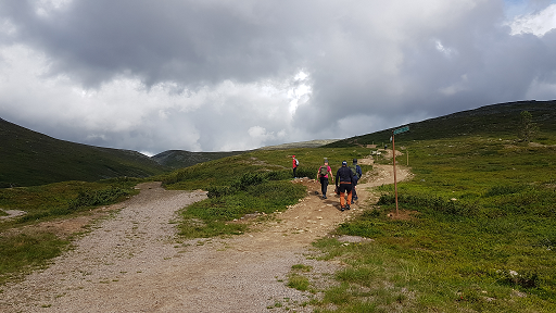
The first stretch is a good warm-up on almost even ground. The trail passes the ruins of a hotel blown up by retreating Germans during WW2. It then starts slowly climbing toward the top. This part of the trail was being improved with gravel and sand, possibly to prevent erosion caused by the increasing number of visitors.
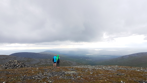
We reached the top in light rain. I recommend good shoes and gear for changing weather, something I didn’t have! It was quite windy too, so no drone footage from this top tour. The top is marked with a pile of rocks and a sign saying the Olympic Fire was lit on this spot in 1952. The views are magnificent and worth a break before heading down.
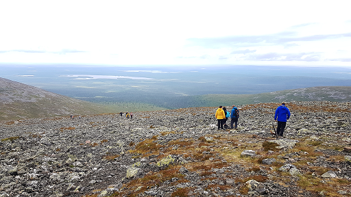
The path down is quite rocky and slippery in rain. When you reach the bottom, you have the easy option to head back to the Visitor Centre following a stream. Our family’s two kids took this option, tempted by the pile of snow on the way. The rest of us continued the trail that now headed up to Laukukero, which is a popular skiing destination in the winter. The trail followed ski lifts all the way back. The descent is steep and rocky in some places.
After-hike activities
After a successful hike you can enjoy well-deserved refreshments at the Pallas Hotel or admire the reindeer in front of the hotel. As we were heading back to our base in Levi, we took the opportunity to explore the Punainenhiekka red sand beach on the way.
Address to Pallastunturi Visitor Centre
Pallastunturintie 557
99330 Muonio
How to get there: Usually by car, bike, motorcycle or bus. For details, see the Pallastunturi Visitor Centre website
When to visit: The trails are walkable in the summer season from June to October.
Accessibility: The visitor centre’s exhibition and auditorium are accessible by wheelchair. The toilets in the visitor centre are accessible to all. The beginning of the Vatikuru trail (1 km) to the ruins of the old hotel and to Pallaskota is accessible by wheelchair with an assistant. Pallaskota is accessible to all. See also: Services in Pallastunturi Visitor Centre