Syöte National Park is located in Pudasjärvi, Posio and Taivalkoski municipalities, in Northern Ostrobothnia and Lapland regions of Finland. Syöte is famous skiing destination because of its two skiing centers at Iso-Syöte and Pikku-Syöte fells, but the national park provides many activities and sights for hikers and nature enthusiasts also in summertime.
Pudasjärvi is a small town with less than 9000 inhabitants, and it’s mainly known for its nature, Iso-Syöte and Pikku-Syöte fells, and Iijoki river. Despite of being small, Pudasjärvi municipality extends to vast area of nearly 6000 square kilometers. It makes Pudasjärvi the eight biggest municipality in the whole Finland. Closest city is Oulu, located approximately 80 kilometers west from Pudasjärvi. From Pudasjärvi to Iso-Syöte it’s about 45 minutes drive. Syöte National Park was established in 2000.
Iso-Syöte is Finland’s southernmost fell
We were visiting Iso-Syöte and Syöte National Park this summer on our way to Lapland. I knew that the trail at the top of Iso-Syöte is called Huippupolku, and it’s only 1 kilometer long trail. The problem was, that there was really no signs saying that anywhere. We parked our car at the hotel parking lot, which apparently is for guests only, and walked behind hotel buildings where we found one trail.
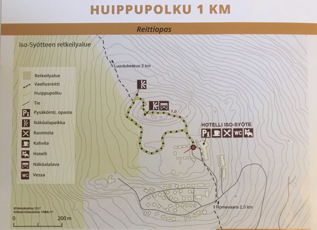
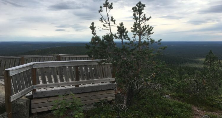
We started walking along that trail and at the same time checked from the map, that we probably came to the trail at the bottom loop. We continued walking the trail anticlockwise, but then the issue was that the trail ended to a fence because of a construction site! How can 1 kilometer long trail be so complicated? Haha! We walked around the construction site by the fence and came to a bigger road leading to the top. We found a little viewing deck about 50 meters behind one building.
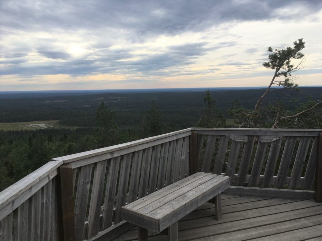
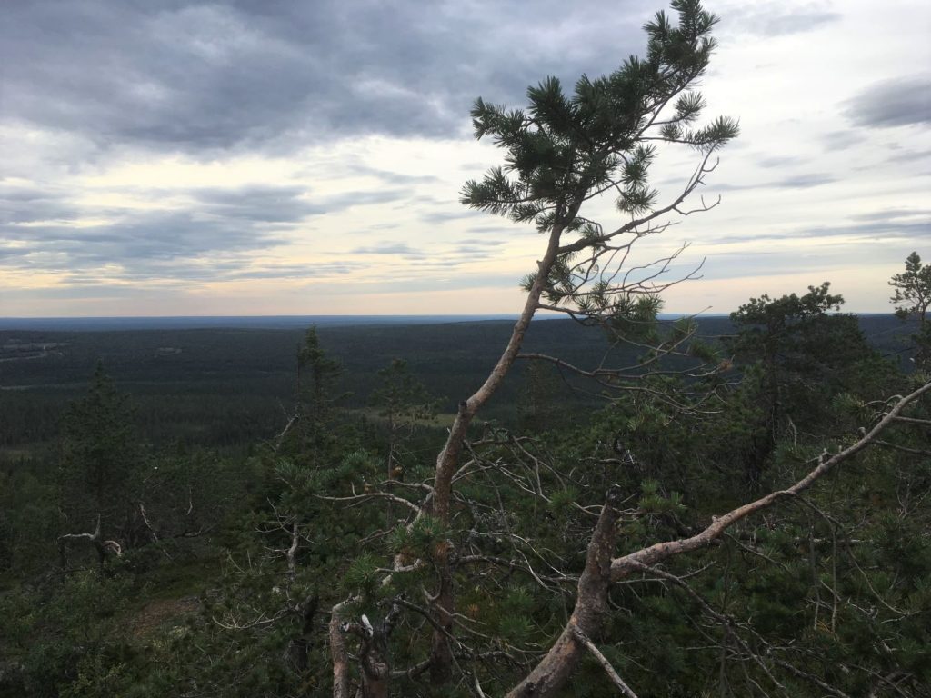
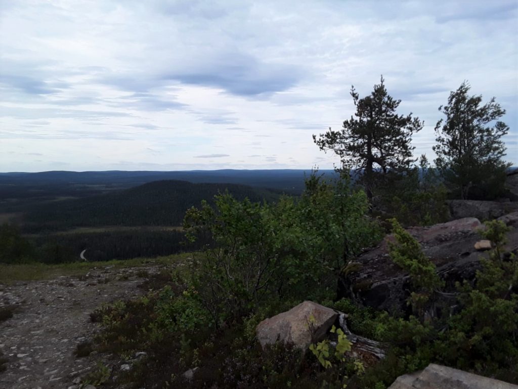
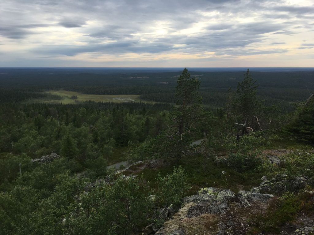
From the top we could see the hotel and also part of the trail, which looked much more simple now when we had made our way to to the top. Iso-Syöte is Finland’s southernmost fell, rising 432 meters above sea level. The word Syöte originates in sámi language and means holy place. The views from Iso-Syöte are exactly what Finland is about; forests, lakes and wetlands.
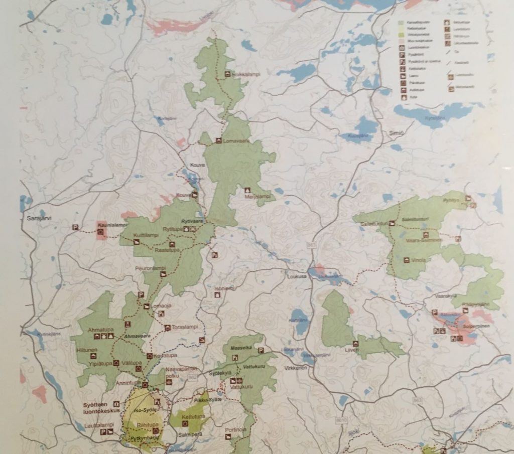
Trails at Syöte National Park
There are 122 kilometers of summer hiking trails around Syöte area and 70 kilometers of bicycle trails. Many trails depart from Syöte Visitor Centre from where you can get maps and up to date information of the trails. The shorter trails are marked with yellow paint, and UKK trekking route has been marked with blue paint.
Hiking trails departuring from Syöte Visitor Centre (Erätie 1, 93280 Pudasjärvi):
- Salojen siivekkäät, 500 m circle trail, available all year round
- Naavaparran polku, 3 km circle trail, available all year round
- Teerivaaran kierros, 4,5 km circle trail, available all year round
- Ahmankierros, 17 km circle trail
- Syötteen kierros, 19 km circle trail
Other hiking trails and their departure points:
- Kellarilampi, 500 m oneway (Rytinkisalmentie 1834, Pudasjärvi)
- Iso-Syöte fell, Huippupolku, 1 km, circle trail (Isosyötteentie 246, Pudasjärvi)
- Pyhitys, 2 km oneway (Ahmaselkosentie 212, Taivalkoski)
- Vattukuru, 2.1 km circle trail (Syötekyläntie 1638, Pudasjärvi)
- Soiperoisen polku, 5 km circle trail (Soiperoisentie 57-59, Taivalkoski)
- Pytkyn pyrähdys, 9 km circle trail (Rytinkisalmentie 1834, Pudasjärvi)
- Rytivaaran kierros, 10 km circle trail (Karsikkoperäntie 1591 Pudasjärvi)
- Torpparintaival, 38 km oneway (Roninkankaantie 6, Pudasjärvi)
Canoeing route:
- River Pärjänjoki Canoe Route, Kuivakoski‒Harriranta, 22 km
incudes rapids I-II (Karsikkoperäntie 861, Pudasjärvi)
Bike trails departuring from Syöte Visitor Centre:
- Ahmankierros, 17 km circle trail
- Syötteen kierros, 19 km circle trail
- Toraslammen taival, 33 km circle trail
- Pitämävaaran lenkki, 35 km circle trail
We rented a cottage from Syöte area and spent one night in here on our way to the north. In the morning we decided to do a short hike close to the cottage before continuing our trip, but I will get back to that nature trail and its sights in another post. It was difficult to choose which trail we would do, I could have spent a whole week at Syöte exploring this national park!
Directions to Iso-Syöte
Address:
Hotel Iso-Syöte
Isosyötteentie 246
93280 Pudasjärvi
How to get there: You can get to the top of Iso-Syöte by walking or by bike, and the closest parking lot is at Hotel Iso-Syöte.
- Car: Arriving from Pudasjärvi keep on driving road 20 towards Kuusamo about 30 km until you see the sign to the National Park. Follow the sign to road 858 and continue for about 25 km to Iso-Syöte.
- Bicycle: Bike routes follow vehicle roads.
- Public transport: Buses operate from Oulu and Pudasjärvi to the Syöte resort during the skiing season. See timetables at Matkahuolto website.
Accessibility: Huippupolku to the top of Iso-Syöte is not accessible for disabled. Salojen siivekkäät nature trail at Syöte National Park is wide and supports wheelchairs. Naavaparran polku trail is also accessible until the Annintupa hut. The accessible trails depart from Syöte Visitor Centre.
When to visit: The trails at Syöte National Park can be accessed during summer and autumn. During winter time snowshoes or skis are essential for moving around the national park due to the snow. Teerivaara and Vattukuru trails are suitable for snowshoes in winter.
What to wear: For short and easy trails hiking shoes aren’t required, but I still recommend a wind breaker jacket when visiting Iso-Syöte fell in summer. It was pretty windy when we wondered there.
Also visit in the area
Rumavaara is a hill that overlooks Korentojärvi lake in Pudasjärvi municipality, about 45 kilometers south from Iso-Syöte. In order to reach Rumavaara, you have to cross its devil’s field first.